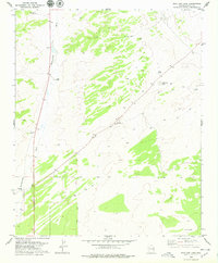
1978 Map of Wild Cow Lake
USGS Topo · Published 1979About this map
Hardscrabble Wash and Brown Wash cut through this arid landscape of Apache County, where the survival of late 1970s ranching operations depended entirely on scattered water sources. This survey documents a critical network of remote infrastructure, including Zuñi Well, Lowery Well, and Burns Well, supporting the isolated Witch Well Ranch in the southwestern corner. The terrain is characterized by a high-desert drainage system feeding into seasonal catchments like Wild Cow Lake. A Radio Facility near the center of the quadrangle serves as a modern landmark amidst a web of Jeep Trails that provided the primary access for land management and local navigation before more significant development reached this portion of the Arizona interior.
Find a feature on this map
28 named features on this map. Tap any name to fly to it.
Don’t see what you’re looking for? This feature index may not catch every label — zoom into the map to look around manually.
Map Details
Editions of this 1978 Wild Cow Lake Map
This is the sole edition of this map. No revisions or reprints were ever made.
Other maps of this area

1886 · St Johns
USGS Topo · 1:250,000

1886 · Fort Defiance
USGS Topo · 1:250,000

1892 · Fort Defiance
USGS Topo · 1:250,000

1892 · St Johns
USGS Topo · 1:250,000

1954 · Saint Johns
USGS Topo · 1:250,000

1954 · Gallup
USGS Topo · 1:250,000

1957 · Saint Johns
USGS Topo · 1:250,000

1958 · Gallup
USGS Topo · 1:250,000

1958 · Saint Johns
USGS Topo · 1:250,000

1959 · Gallup
USGS Topo · 1:250,000