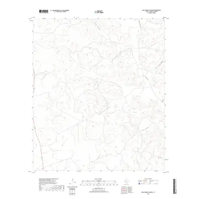
2019 Map of Wild Horse Canyon
USGS Topo · Published 2019About this map
Wild Horse Canyon and the surrounding drainage network define this 2019 survey of the West Texas landscape in Crockett County. The area is characterized by an intricate system of dry washes and canyons, including the notably named Jesus Draw and Bull Clod Draw. This geography reflects the traditional ranching environment of the Edwards Plateau, where water management and seasonal runoff dictate the use of the land. Human presence is sparse, anchored primarily by the transit corridor of State Highway 163 along the western edge and local access routes like Taylor Box Road. Other significant natural landmarks such as Shaggy Canyon, Little Shaggy Canyon, and Jackson Draw illustrate the deeply dissected terrain that has shaped local land boundaries and movement for generations. The U.S. Geological Survey used 2016 NAIP imagery to document these features, providing a precise record of the contemporary landscape.
Find a feature on this map
10 named features on this map. Tap any name to fly to it.
Don’t see what you’re looking for? This feature index may not catch every label — zoom into the map to look around manually.
Map Details
Editions of this 2019 Wild Horse Canyon Map
This is the sole edition of this map. No revisions or reprints were ever made.
Other maps of this area

1954 · Sonora
USGS Topo · 1:250,000

1958 · Sonora
USGS Topo · 1:250,000

1967 · Baggett Ranch
USGS Topo · 1:24,000

1967 · Flat Rock Draw SW
USGS Topo · 1:24,000

1967 · Ozona SE
USGS Topo · 1:24,000

1967 · Shafter Draw
USGS Topo · 1:24,000
1967 · Hospital Ranch
USGS Topo · 1:24,000

1969 · Wild Horse Canyon
USGS Topo · 1:24,000

1970 · Indian Draw
USGS Topo · 1:24,000

1970 · Brushy Draw
USGS Topo · 1:24,000