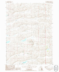
1986 Map of Wild Horse Hill
USGS Topo · Published 1986About this map
The Nebraska Sandhills define the landscape in this mid-1980s survey of Grant County, where the terrain is dominated by a series of northwest-to-southeast trending depressions. These features, including Van Nortwick Valley and Pleasant Valley, characterize the grazing lands of the region. Significant landmarks such as Wild Horse Hill rise above the interdunal basins, while isolated water bodies like Dominick Lake and Swede Lake provide critical resources in this arid environment. The map documents the rural settlement patterns of the era, specifically identifying family-held operations such as the Burgess Ranch, Arthur Dubs Ranch, and Rudolph Dubs Ranch. A lone Radio Facility near the center of the sheet reflects the infrastructure needed for communication across these open plains. The survey also captures the transition between Big Swede Valley and Little Swede Valley, illustrating the subtle topographic shifts that dictate land use in this part of the state.
Find a feature on this map
15 named features on this map. Tap any name to fly to it.
Don’t see what you’re looking for? This feature index may not catch every label — zoom into the map to look around manually.
Map Details
Editions of this 1986 Wild Horse Hill Map
This is the sole edition of this map. No revisions or reprints were ever made.
Other maps of this area

1948 · Ashby
USGS Topo · 1:62,500

1948 · Bingham
USGS Topo · 1:62,500

1948 · George Lake
USGS Topo · 1:62,500

1949 · Ashby
USGS Topo · 1:62,500

1950 · George Lake
USGS Topo · 1:62,500

1950 · Longfellow Lake
USGS Topo · 1:62,500

1950 · Bingham
USGS Topo · 1:62,500

1954 · Scottsbluff
USGS Topo · 1:250,000

1954 · North Platte
USGS Topo · 1:250,000

1955 · Alliance
USGS Topo · 1:250,000