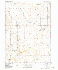
1951 Map of Wild Horse Lake
USGS Topo · Published 1976About this map
The Yenter Pool petroleum field dominates the eastern landscape of this Logan County survey, marking a period of intense oil exploration in northeastern Colorado. This industrial development is evidenced by a dense concentration of Oil Wells and Oil Tanks clustered around the pool. Contrastingly, the western and central portions of the map reflect the region's ranching roots, dotted with numerous Windmill sites necessary for tapping groundwater in this arid environment.
Find a feature on this map
20 named features on this map. Tap any name to fly to it.
Don’t see what you’re looking for? This feature index may not catch every label — zoom into the map to look around manually.
Map Details
Editions of this 1951 Wild Horse Lake Map
2 editions found
Other maps of this area

1951 · Willard
USGS Topo · 1:24,000

1951 · Wild Horse Lake
USGS Topo · 1:24,000

1951 · Atwood NE
USGS Topo · 1:24,000

1951 · Atwood
USGS Topo · 1:24,000

1954 · Sterling
USGS Topo · 1:250,000

1958 · Sterling
USGS Topo · 1:250,000

1977 · Stoneham NE
USGS Topo · 1:24,000

1977 · Avalo SE
USGS Topo · 1:24,000
1978 · North Sterling Reservoir
USGS Topo · 1:24,000
1978 · Stoneham SE
USGS Topo · 1:24,000