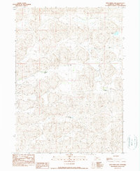
1990 Map of Wild Mare Lake
USGS Topo · Published 1990About this map
Wild Mare Lake and the surrounding Sandhills of Cherry County are shown here as they appeared during a 1988 field check. This ranching landscape is defined by its intermittent water bodies and isolated outposts, reflecting the specialized cattle operations of the Nebraska plains. Large-scale ranching is anchored by properties like Churn Ranch and Shadbolt Ranch, while Fairbanks Camp suggests the seasonal or operational movement of ranch hands across the vast terrain. The hydrology is dominated by Medicine Creek and small basins such as Heath Lake, which are critical resources in this semi-arid environment. Compiled from 1984 aerial photography, the map documents a sparse settlement pattern where roads are largely unimproved and land management is organized around the township and range system, specifically the boundary between T 32 N and T 31 N.
Find a feature on this map
8 named features on this map. Tap any name to fly to it.
Don’t see what you’re looking for? This feature index may not catch every label — zoom into the map to look around manually.
Map Details
Editions of this 1990 Wild Mare Lake Map
This is the sole edition of this map. No revisions or reprints were ever made.
Other maps of this area

1950 · Doughboy
USGS Topo · 1:62,500

1951 · Merriman
USGS Topo · 1:62,500

1951 · Merriman 4
USGS Topo · 1:62,500

1952 · Eli
USGS Topo · 1:62,500

1952 · Doughboy
USGS Topo · 1:62,500

1957 · Valentine
USGS Topo · 1:250,000

1959 · Valentine
USGS Topo · 1:250,000

1985 · Cody
USGS Topo · 1:100,000
1985 · Eli SW
USGS Topo · 1:24,000
1985 · Medicine Lake
USGS Topo · 1:24,000