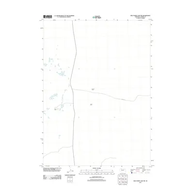
2011 Map of Wild Mare Lake NW
USGS Topo · Published 2011About this map
MacBeth Ranch and other family-named cattle operations define this sparsely populated landscape in the Nebraska Sandhills. Located in the northern reaches of Cherry County, the terrain is characterized by numerous small lakes and basins typical of this region's complex hydrography. Transport through this expansive prairie is limited to isolated corridors like Shadbolt Rd, which connects the Jensen Ranch and Leach Ranch to the broader regional network. The distribution of these ranch sites illustrates the vast acreage required for livestock management in this part of the state, where few permanent structures exist outside of these established headquarters.
Find a feature on this map
4 named features on this map. Tap any name to fly to it.
Don’t see what you’re looking for? This feature index may not catch every label — zoom into the map to look around manually.
Map Details
Editions of this 2011 Wild Mare Lake NW Map
This is the sole edition of this map. No revisions or reprints were ever made.
Other maps of this area

1950 · Irwin
USGS Topo · 1:62,500

1951 · Irwin
USGS Topo · 1:62,500

1951 · Gypsy Valley
USGS Topo · 1:62,500

1951 · Merriman
USGS Topo · 1:62,500

1951 · Merriman 4
USGS Topo · 1:62,500

1957 · Valentine
USGS Topo · 1:250,000

1959 · Valentine
USGS Topo · 1:250,000

1985 · Cody
USGS Topo · 1:100,000
1990 · Wild Mare Lake SW
USGS Topo · 1:24,000
1990 · North Valley
USGS Topo · 1:24,000