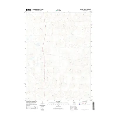
2014 Map of Wild Mare Lake NW
USGS Topo · Published 2014About this map
Nebraska's Sandhills define the landscape of this 2014 survey in Cherry County, where the topography is shaped by countless depressions and ridges. Unlike more densely settled regions, this area is characterized by its sparse infrastructure, primarily centered around the north-south corridor of Ne-61. This highway provides the principal route through the undulating terrain, intersecting with Shadbolt Rd as it cuts across the section. The map illustrates the specialized land-use patterns of the High Plains, where the lack of clustered towns or schools points to a ranching economy dependent on large, open tracts of land. For those studying the geography of north-central Nebraska, the sheet captures the specific layout of local roads and the intricate relief of the dunes before any further modern development altered the drainage and access patterns of this interior region.
Find a feature on this map
2 named features on this map. Tap any name to fly to it.
Don’t see what you’re looking for? This feature index may not catch every label — zoom into the map to look around manually.
Map Details
Editions of this 2014 Wild Mare Lake NW Map
This is the sole edition of this map. No revisions or reprints were ever made.
Other maps of this area

1950 · Irwin
USGS Topo · 1:62,500

1951 · Irwin
USGS Topo · 1:62,500

1951 · Gypsy Valley
USGS Topo · 1:62,500

1951 · Merriman
USGS Topo · 1:62,500

1951 · Merriman 4
USGS Topo · 1:62,500

1957 · Valentine
USGS Topo · 1:250,000

1959 · Valentine
USGS Topo · 1:250,000

1985 · Cody
USGS Topo · 1:100,000
1990 · Wild Mare Lake SW
USGS Topo · 1:24,000
1990 · North Valley
USGS Topo · 1:24,000