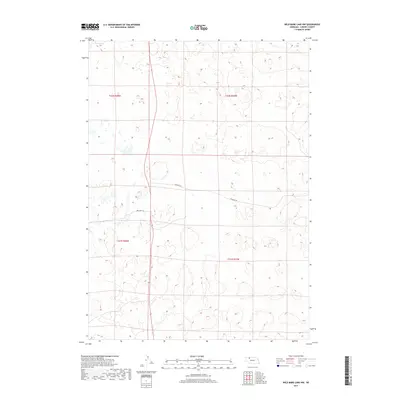
2017 Map of Wild Mare Lake NW
USGS Topo · Published 2017About this map
Shadbolt Rd and One Lane Trl provide the primary human transit points across this sparsely populated section of Cherry County. The landscape is defined by the Public Land Survey System divisions of t31n r37w, t31n r38w, t32n r37w, and t32n r38w, reflecting the rectilinear organization of the Nebraska Sandhills. Small, scattered wetlands and ephemeral water bodies are characteristic of this terrain, often found in the depressions between dunes. The map's detail shows how minimal infrastructure, primarily unpaved roads and trails, serves the remote ranching operations that historically dominate this portion of the northern plains.
Find a feature on this map
6 named features on this map. Tap any name to fly to it.
Don’t see what you’re looking for? This feature index may not catch every label — zoom into the map to look around manually.
Map Details
Editions of this 2017 Wild Mare Lake NW Map
This is the sole edition of this map. No revisions or reprints were ever made.
Other maps of this area

1950 · Irwin
USGS Topo · 1:62,500

1951 · Irwin
USGS Topo · 1:62,500

1951 · Gypsy Valley
USGS Topo · 1:62,500

1951 · Merriman
USGS Topo · 1:62,500

1951 · Merriman 4
USGS Topo · 1:62,500

1957 · Valentine
USGS Topo · 1:250,000

1959 · Valentine
USGS Topo · 1:250,000

1985 · Cody
USGS Topo · 1:100,000
1990 · Wild Mare Lake SW
USGS Topo · 1:24,000
1990 · North Valley
USGS Topo · 1:24,000