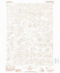
1990 Map of Wild Mare Lake NW
USGS Topo · Published 1990About this map
Jensen Ranch stands as the primary landmark in this 1990 survey of the Nebraska Sandhills. The landscape is defined by its complex, undulating dune topography, which creates a pattern of isolated depressions and dry valleys across the Wild Mare Lake NW quadrangle. This provisional mapping reflects the vast, open cattle country of Cherry County as it appeared in the late twentieth century, showing a region where human infrastructure is secondary to the natural drainage and landforms. The intricate contour work illustrates the difficulty of navigating this terrain, where small ranch tracks provide the only connection between remote locations.
Find a feature on this map
1 named feature on this map. Tap any name to fly to it.
Don’t see what you’re looking for? This feature index may not catch every label — zoom into the map to look around manually.
Map Details
Editions of this 1990 Wild Mare Lake NW Map
This is the sole edition of this map. No revisions or reprints were ever made.
Other maps of this area

1950 · Irwin
USGS Topo · 1:62,500

1951 · Irwin
USGS Topo · 1:62,500

1951 · Gypsy Valley
USGS Topo · 1:62,500

1951 · Merriman
USGS Topo · 1:62,500

1951 · Merriman 4
USGS Topo · 1:62,500

1957 · Valentine
USGS Topo · 1:250,000

1959 · Valentine
USGS Topo · 1:250,000

1985 · Cody
USGS Topo · 1:100,000
1990 · Wild Mare Lake SW
USGS Topo · 1:24,000
1990 · North Valley
USGS Topo · 1:24,000