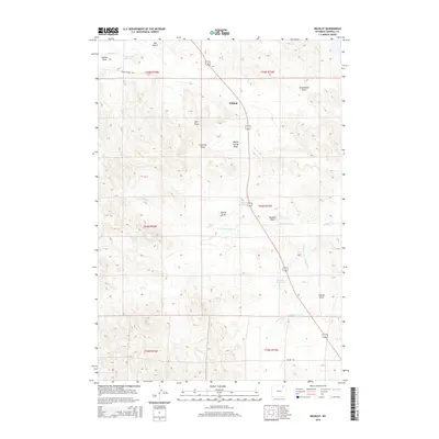
2015 Map of Wildcat
USGS Topo · Published 2015About this map
The high plains of Campbell County are defined by a network of seasonal drainage basins and small water impoundments, centered on the location of Wildcat. The landscape is etched by numerous named ephemeral channels, known locally as draws, such as Ruff Draw, Homestead Draw, and Soukup Draw. These features, along with Dry Gulch and Gibbon Draw, illustrate the complex erosion patterns and water management required in this arid Wyoming environment. Significant water resources like Horse Cr Reservoir, Scott Reservoir, and Fletcher Reservoir provide essential catchment points along the N Fork Wildcat Cr and its tributaries.
Find a feature on this map
25 named features on this map. Tap any name to fly to it.
Don’t see what you’re looking for? This feature index may not catch every label — zoom into the map to look around manually.
Map Details
Editions of this 2015 Wildcat Map
This is the sole edition of this map. No revisions or reprints were ever made.
Other maps of this area

1954 · Gillette
USGS Topo · 1:250,000

1955 · Gillette
USGS Topo · 1:250,000

1958 · Gillette
USGS Topo · 1:250,000

1962 · Gillette
USGS Topo · 1:250,000

1971 · Wildcat
USGS Topo · 1:24,000

1971 · Oriva NW
USGS Topo · 1:24,000
1971 · Pitch Draw
USGS Topo · 1:24,000

1971 · Recluse
USGS Topo · 1:24,000
1971 · Calf Creek
USGS Topo · 1:24,000
1971 · Rawhide School
USGS Topo · 1:24,000