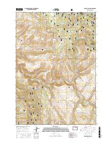
2017 Map of Wildcat Point
USGS Topo · Published 2017About this map
The Middle Fork John Day River winds through the central portion of this landscape, marking a significant hydrologic divide between the Umatilla National Forest to the north and the Malheur National Forest to the south. Historically significant landmarks include the Willow Creek Cem located near the base of Willow Creek Butte, providing a tangible link to early residents. The terrain is characterized by complex drainage systems and named features such as Paradise Canyon, Bum Canyon, and Patterson Basin. Transportation in the area relies on a network of established forest roads and county routes, including Co Rd 20 and the Long Creek-Pass Creek Rd. Smaller seasonal streams like Huckleberry Cr and Bully Cr feed into the larger river system, defining the steep-sided gulches such as Board Gulch and Troutman Gulch.
Find a feature on this map
43 named features on this map. Tap any name to fly to it.
Don’t see what you’re looking for? This feature index may not catch every label — zoom into the map to look around manually.
Map Details
Editions of this 2017 Wildcat Point Map
This is the sole edition of this map. No revisions or reprints were ever made.
Other maps of this area

1949 · Long Creek
USGS Topo · 1:62,500

1949 · Susanville
USGS Topo · 1:62,500

1950 · Ritter
USGS Topo · 1:62,500

1951 · Susanville
USGS Topo · 1:62,500

1951 · Long Creek
USGS Topo · 1:62,500

1951 · Dale
USGS Topo · 1:62,500

1952 · Ritter
USGS Topo · 1:62,500

1955 · Canyon City
USGS Topo · 1:250,000

1959 · Canyon City
USGS Topo · 1:250,000

1980 · Monument
USGS Topo · 1:100,000