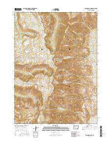
2017 Map of Wildhorse Lake
USGS Topo · Published 2017About this map
Steens Mtn dominates this high-altitude landscape in Harney County, where the dramatic relief of the Great Basin is on full display. The crest of the mountain serves as a significant drainage divide, with water flowing west via the Little Blitzen River and east toward the Alvord Desert through steep descents like Wildhorse Canyon. Glacial action is evident in the deep U-shaped profile of Kiger Gorge and the presence of high-elevation tarns including Wildhorse Lake and Little Wildhorse Lake. Human presence is limited to the winding path of Steens Mountain Rd, which provides access to these remote heights. The map tracks numerous seasonal and perennial water sources, from the headwaters of Kiger Cr and Mosquito Cr to the eastern reaches of Big Alvord Cr, illustrating the complex hydrology of this arid but ecologically vital massif.
Find a feature on this map
31 named features on this map. Tap any name to fly to it.
Don’t see what you’re looking for? This feature index may not catch every label — zoom into the map to look around manually.
Map Details
Editions of this 2017 Wildhorse Lake Map
This is the sole edition of this map. No revisions or reprints were ever made.
Other maps of this area

1955 · Adel
USGS Topo · 1:250,000

1957 · Adel
USGS Topo · 1:250,000

1958 · Adel
USGS Topo · 1:250,000

1962 · Adel
USGS Topo · 1:250,000

1968 · Fish Lake
USGS Topo · 1:24,000

1968 · Wildhorse Lake
USGS Topo · 1:24,000

1968 · Big Pasture Creek
USGS Topo · 1:24,000

1968 · Alvord Hot Springs
USGS Topo · 1:24,000

1968 · Ankle Creek
USGS Topo · 1:24,000
1968 · Mc Coy Ridge
USGS Topo · 1:24,000