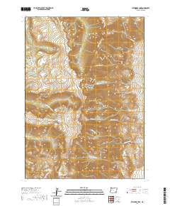
2020 Map of Wildhorse Lake
USGS Topo · Published 2020About this map
Steens Mtn dominates this high-elevation landscape in Harney County, where the dramatic glacial carving of Kiger Gorge and Wildhorse Canyon illustrates a complex geological history. The area serves as a significant hydrological headwaters region, with numerous drainage systems radiating from the central peaks. To the west, the Little Blitzen River and Big Indian Cr flow through deep canyons, while the eastern slopes are defined by the steep descent of Cottonwood Cr and Big Alvord Cr. High alpine water bodies including Wildhorse Lake and Little Wildhorse Lake are focal points of the terrain. Human presence is marked by Jackman Park and the winding Steens Mountain Rd, providing access to these remote landmarks. The map also identifies notable features like Devine Rock and the upper reaches of Kiger Cr, detailing a landscape of extreme vertical relief and seasonal watercourses.
Find a feature on this map
32 named features on this map. Tap any name to fly to it.
Don’t see what you’re looking for? This feature index may not catch every label — zoom into the map to look around manually.
Map Details
Editions of this 2020 Wildhorse Lake Map
This is the sole edition of this map. No revisions or reprints were ever made.
Other maps of this area

1955 · Adel
USGS Topo · 1:250,000

1957 · Adel
USGS Topo · 1:250,000

1958 · Adel
USGS Topo · 1:250,000

1962 · Adel
USGS Topo · 1:250,000

1968 · Fish Lake
USGS Topo · 1:24,000

1968 · Wildhorse Lake
USGS Topo · 1:24,000

1968 · Big Pasture Creek
USGS Topo · 1:24,000

1968 · Alvord Hot Springs
USGS Topo · 1:24,000

1968 · Ankle Creek
USGS Topo · 1:24,000
1968 · Mc Coy Ridge
USGS Topo · 1:24,000