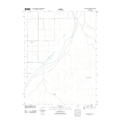
2011 Map of Wildhorse Pass
USGS Topo · Published 2011About this map
The Humboldt River winds through this arid landscape of western Nevada, where irrigation infrastructure dominates the valley floor. Settled agricultural activity is concentrated at family-named outposts like Tule Ranch and Cottonwood Ranch, connected by a geometric grid of local routes such as Reservation Rd and S Meridian Rd. The map illustrates the region's total dependence on water management, evidenced by the extensive network of canals including Seven Ditch, Sommers Ditch, and the Big Five Canal, which feeds the Big Five Reservoir. To the south and east, the terrain rises sharply into the West Humboldt Range, where the natural gap of Wildhorse Pass provides a transition from the river basin into the higher desert reaches. This 2011 survey captures the enduring layout of Churchill County's hydraulic engineering and ranching heritage.
Find a feature on this map
18 named features on this map. Tap any name to fly to it.
Don’t see what you’re looking for? This feature index may not catch every label — zoom into the map to look around manually.
Map Details
Editions of this 2011 Wildhorse Pass Map
This is the sole edition of this map. No revisions or reprints were ever made.
Other maps of this area

1908 · Carson Sink
USGS Topo · 1:250,000

1910 · Carson Sink
USGS Topo · 1:250,000

1931 · Lovelock
USGS Topo · 1:250,000

1935 · Lovelock
USGS Topo · 1:250,000

1951 · Carson Sink
USGS Topo · 1:62,500

1955 · Lovelock
USGS Topo · 1:250,000

1956 · Toulon
USGS Topo · 1:62,500

1956 · Lovelock
USGS Topo · 1:62,500

1957 · Reno
USGS Topo · 1:250,000

1959 · Lovelock
USGS Topo · 1:250,000