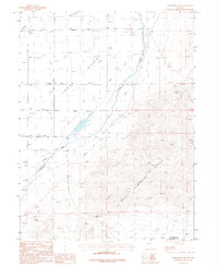
1987 Map of Wildhorse Pass
USGS Topo · Published 1988About this map
Lower Valley agriculture and the mountain mining prospects of the West Humboldt Range define this 1980s landscape at the border of Pershing and Churchill counties. Water management dominates the western flats, where the Humboldt River is supported by an intricate system of irrigation including the Big Five Canal, Seventeen Mile Ditch, and Army Derby Drain. These features reflect the long-standing effort to harness the river for valley farming.
Find a feature on this map
20 named features on this map. Tap any name to fly to it.
Don’t see what you’re looking for? This feature index may not catch every label — zoom into the map to look around manually.
Map Details
Editions of this 1987 Wildhorse Pass Map
This is the sole edition of this map. No revisions or reprints were ever made.
Other maps of this area

1908 · Carson Sink
USGS Topo · 1:250,000

1910 · Carson Sink
USGS Topo · 1:250,000

1931 · Lovelock
USGS Topo · 1:250,000

1935 · Lovelock
USGS Topo · 1:250,000

1951 · Carson Sink
USGS Topo · 1:62,500

1955 · Lovelock
USGS Topo · 1:250,000

1956 · Toulon
USGS Topo · 1:62,500

1956 · Lovelock
USGS Topo · 1:62,500

1957 · Reno
USGS Topo · 1:250,000

1959 · Lovelock
USGS Topo · 1:250,000