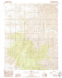
1988 Map of Wildrose Peak
USGS Topo · Published 1988About this map
Harrisburg anchors the northwest corner of this desert landscape, situated near the expanse of the Harrisburg Flats. During the late twentieth century, this region within the Death Valley National Monument remained a site of significant geological interest, marked by numerous mining operations and high-elevation peaks. The topographic detail highlights a history of extraction with the Napoleon Mine and Argenta Mine nestled among the steep ridges. Vertical relief is dramatic, rising from deep incisions like Wood Canyon and Nemo Canyon to prominent summits including Bald Peak and the namesake Wildrose Peak. To the east, Aguereberry Point offers a vantage over the vast drainage networks of Death Valley Canyon and the South Fork, illustrating the complex erosional patterns of the Inyo County highlands.
Find a feature on this map
20 named features on this map. Tap any name to fly to it.
Don’t see what you’re looking for? This feature index may not catch every label — zoom into the map to look around manually.
Map Details
Editions of this 1988 Wildrose Peak Map
2 editions found
Other maps of this area

1908 · Furnace Creek
USGS Topo · 1:250,000

1908 · Ballarat
USGS Topo · 1:250,000

1910 · Furnace Creek
USGS Topo · 1:250,000

1913 · Ballarat
USGS Topo · 1:250,000

1948 · Death Valley
USGS Topo · 1:250,000

1952 · Furnace Creek
USGS Topo · 1:62,500

1952 · Bennetts Well
USGS Topo · 1:62,500

1952 · Telescope Peak
USGS Topo · 1:62,500

1952 · Emigrant Canyon
USGS Topo · 1:62,500

1954 · Death Valley
USGS Topo · 1:250,000