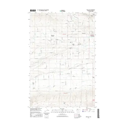
2017 Map of Wiley City
USGS Topo · Published 2017About this map
The agricultural valleys and rising ridges west of Yakima are defined by an intricate network of irrigation systems, including the Ahtanum Canal and several laterals that sustain the orchards and fields of the Ahtanum Valley. Central to this landscape is Wiley City, surrounded by the small rural settlements of Harwood, Gromore, and Tietonview Grange. The map reveals a high concentration of cultural sites, particularly cemeteries like Saluskin Cem, Wah-Lal-La-Kite Cem, and Emeunot Cem, which underscore the region's deep indigenous and pioneer history.
Find a feature on this map
123 named features on this map. Tap any name to fly to it.
Don’t see what you’re looking for? This feature index may not catch every label — zoom into the map to look around manually.
Map Details
Editions of this 2017 Wiley City Map
This is the sole edition of this map. No revisions or reprints were ever made.
Other maps of this area

1899 · Ellensburg
USGS Topo · 1:125,000

1901 · Ellensburg
USGS Topo · 1:125,000

1937 · White Swan
USGS Topo · 1:125,000

1950 · Yakima
USGS Topo · 1:250,000

1958 · Harrah
USGS Topo · 1:24,000
1958 · Yakima West
USGS Topo · 1:24,000
1958 · Selah
USGS Topo · 1:24,000

1958 · Fort Simcoe
USGS Topo · 1:62,500

1958 · Wiley City
USGS Topo · 1:24,000

1958 · White Swan
USGS Topo · 1:24,000