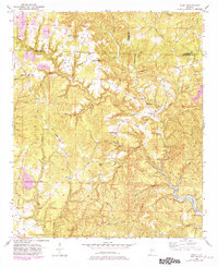
1949 Map of Wiley
USGS Topo · Published 1981About this map
Upper Sulphur Springs Church and the nearby Lower Sulphur Springs Church anchor a landscape defined by the winding drainages of the Alabama hill country during the late 1940s. The terrain is a complex network of ridges and hollows, where small settlements like Sandtown and Wiley are connected by narrow routes such as Sterling Rd and Cheatham Road. The local economy of this era is visible through the presence of a Strip Mine near the northern boundary, signifying the industrial transition of the coal-rich region. To the southeast, the wide waters of Bankhead Lake mark the confluence of Big Yellow Creek and other major tributaries. Genealogists will find significant detail in the placement of the Brandon Sch, the Earnest Cem, and the Flatwoods Cem, providing a precise look at the community structure of Tuscaloosa and Fayette counties before later 20th-century development.
Find a feature on this map
50 named features on this map. Tap any name to fly to it.
Don’t see what you’re looking for? This feature index may not catch every label — zoom into the map to look around manually.
Map Details
Editions of this 1949 Wiley Map
3 editions found
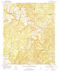
Other maps of this area

1893 · Jasper
USGS Topo · 1:125,000

1899 · Brookwood
USGS Topo · 1:125,000

1926 · Samantha
USGS Topo · 1:48,000

1928 · Samantha
USGS Topo · 1:62,500

1929 · Searles
USGS Topo · 1:48,000

1934 · Searles
USGS Topo · 1:62,500

1949 · Parrish
USGS Topo · 1:24,000

1949 · Oakman
USGS Topo · 1:24,000

1949 · Tutwiler School
USGS Topo · 1:24,000

1949 · Wiley
USGS Topo · 1:24,000