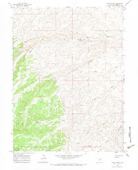
1965 Map of Wilkin Ridge
USGS Topo · Published 1983About this map
Wilkin Ridge dominates this mid-1960s landscape, illustrating the complex drainage patterns of Duchesne County through a series of named erosional features like Big Wash and Sheep Wash. The presence of a Pipeline and a Drill Hole signifies the industrial footprint of resource exploration during the post-war era. To the southeast, the terrain opens into the Little Desert, a stark contrast to the higher elevations marked by Horner Knoll and Twin Knolls. For those researching local travel routes, the map identifies established pathways such as the Fourmile Trail and various Jeep Trails, which provided essential access to remote water sources like White Mule Spring across this arid terrain.
Find a feature on this map
15 named features on this map. Tap any name to fly to it.
Don’t see what you’re looking for? This feature index may not catch every label — zoom into the map to look around manually.
Map Details
Editions of this 1965 Wilkin Ridge Map
2 editions found
Other maps of this area

1885 · East Tavaputs
USGS Topo · 1:250,000

1885 · Ashley
USGS Topo · 1:250,000

1885 · Uinta
USGS Topo · 1:250,000

1886 · Price River
USGS Topo · 1:250,000

1896 · Price River
USGS Topo · 1:250,000

1917 · Vernal
USGS Topo · 1:125,000

1939 · Duchesne
USGS Topo · 1:125,000

1953 · Nutters Hole
USGS Topo · 1:62,500

1954 · Salt Lake City
USGS Topo · 1:250,000

1954 · Vernal
USGS Topo · 1:250,000