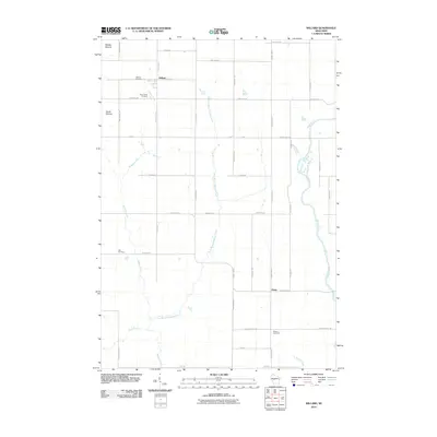
2010 Map of Willard
USGS Topo · Published 2010About this map
The small community of Willard serves as a focal point for this rural Clark County landscape, where the agricultural grid meets the winding course of the Black River. This area is characterized by a high concentration of burial grounds, including the Holy Family Cemetery and Willard Cemetery near the town site, as well as Seif Cemetery and Weston Cemetery further afield. These sites provide valuable touchstones for genealogists tracing family histories in the region. The terrain is marked by prominent elevations like Middle Mound and South Mound in the northwest, which contrast with the drainage basins of Wedges Creek and its East Branch. The settlement pattern follows a strict network of rural roads such as Heintown Rd and Chili Rd, connecting small hamlets like Globe to the broader county infrastructure.
Find a feature on this map
38 named features on this map. Tap any name to fly to it.
Don’t see what you’re looking for? This feature index may not catch every label — zoom into the map to look around manually.
Map Details
Editions of this 2010 Willard Map
This is the sole edition of this map. No revisions or reprints were ever made.
Other maps of this area

1948 · Fairchild
USGS Topo · 1:62,500

1949 · Fairchild
USGS Topo · 1:62,500

1952 · Stanley
USGS Topo · 1:62,500

1953 · Neillsville
USGS Topo · 1:62,500

1953 · Owen
USGS Topo · 1:48,000

1953 · Eau Claire
USGS Topo · 1:250,000

1958 · Eau Claire
USGS Topo · 1:250,000

1963 · Owen
USGS Topo · 1:62,500

1964 · Eau Claire
USGS Topo · 1:250,000
1979 · Wildcat Mound
USGS Topo · 1:24,000