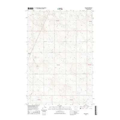
2017 Map of Willard
USGS Topo · Published 2017About this map
Willard stands as the primary settlement in this corner of Fallon County, where the plains are etched by a complex network of seasonal drainages and local thoroughfares. The landscape is defined by the branching courses of S Fork Sandstone Cr and Little Beaver Cr, which dictate the placement of ranch roads and trails. Historical transit routes like the Old Baker Hwy and Bergstrom Hill Rd provide a clear view of how land ownership and access were organized across various townships, including t6n r59e and t5n r60e. The map highlights the high-plains topography through named features like the Wiley Butte Trl, illustrating the intersection of natural watercourses like Hidden Water Cr and Richards Cr with the section-line road grid that characterizes this Montana ranching country.
Find a feature on this map
22 named features on this map. Tap any name to fly to it.
Don’t see what you’re looking for? This feature index may not catch every label — zoom into the map to look around manually.
Map Details
Editions of this 2017 Willard Map
This is the sole edition of this map. No revisions or reprints were ever made.
Other maps of this area

1953 · Miles City
USGS Topo · 1:250,000

1957 · Miles City
USGS Topo · 1:250,000

1958 · Miles City
USGS Topo · 1:250,000

1981 · Webster NW
USGS Topo · 1:24,000

1981 · Baker
USGS Topo · 1:100,000

1981 · Buffalo Reservoir
USGS Topo · 1:24,000

1981 · Baker
USGS Topo · 1:24,000

1981 · South Sandstone Reservoir
USGS Topo · 1:24,000

1981 · Willard
USGS Topo · 1:24,000
1981 · Willard SE
USGS Topo · 1:24,000