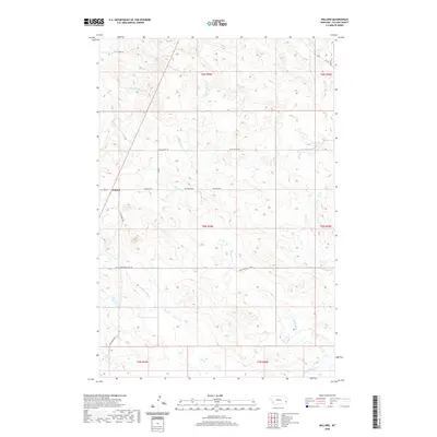
2020 Map of Willard
USGS Topo · Published 2020About this map
Willard serves as the focal point for this section of Fallon County, where the high plains are carved by a complex network of intermittent drainages. The landscape is defined by the branching tributaries of Little Beaver Cr and S Fork Sandstone Cr, illustrating the vital role of water management in eastern Montana. Local transport and cattle routes are well-defined by legacy names such as Bergstrom Hill Rd and Wiley Butte Trl, which connect the scattered rangelands. Further south, the terrain descends toward the N Fork of Dry Cr and Duck Cr. This 2020 edition provides a clear picture of the modern rural infrastructure, showing how the Old Baker Hwy and Willow Rd E maintain the connectivity of this agricultural region.
Find a feature on this map
21 named features on this map. Tap any name to fly to it.
Don’t see what you’re looking for? This feature index may not catch every label — zoom into the map to look around manually.
Map Details
Editions of this 2020 Willard Map
This is the sole edition of this map. No revisions or reprints were ever made.
Other maps of this area

1953 · Miles City
USGS Topo · 1:250,000

1957 · Miles City
USGS Topo · 1:250,000

1958 · Miles City
USGS Topo · 1:250,000

1981 · Webster NW
USGS Topo · 1:24,000

1981 · Baker
USGS Topo · 1:100,000

1981 · Buffalo Reservoir
USGS Topo · 1:24,000

1981 · Baker
USGS Topo · 1:24,000

1981 · South Sandstone Reservoir
USGS Topo · 1:24,000

1981 · Willard
USGS Topo · 1:24,000
1981 · Willard SE
USGS Topo · 1:24,000