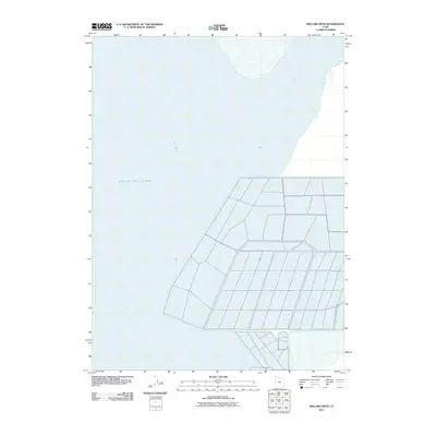
2011 Map of Willard Spur
USGS Topo · Published 2011About this map
Great Salt Lake dominates the western reaches of this 2011 survey, showing the expansive shoreline and aquatic boundaries of Bear River Bay and the Willard Spur. The map provides a precise view of the complex water-management and dike structures that define this portion of the northern lakebed. These man-made features create a geometric contrast against the open waters and marshy shallows, illustrating the intersection of natural hydrology and engineering within the Weber County basin. The detailed layout of dikes and access roads reflects the ongoing efforts to manage the wetlands and water levels at the confluence where river systems meet the Great Salt Lake's terminal basin.
Find a feature on this map
3 named features on this map. Tap any name to fly to it.
Don’t see what you’re looking for? This feature index may not catch every label — zoom into the map to look around manually.
Map Details
Editions of this 2011 Willard Spur Map
This is the sole edition of this map. No revisions or reprints were ever made.
Other maps of this area

1954 · Whistler Canal
USGS Topo · 1:24,000

1954 · Brigham City
USGS Topo · 1:250,000

1955 · Willard Spur
USGS Topo · 1:24,000

1955 · Mouth of Bear River
USGS Topo · 1:24,000

1955 · Plain City SW
USGS Topo · 1:24,000

1955 · Ogden Bay
USGS Topo · 1:24,000

1955 · Fremont Island
USGS Topo · 1:24,000

1958 · Brigham City
USGS Topo · 1:250,000

1962 · Brigham City
USGS Topo · 1:250,000

1967 · East Promontory
USGS Topo · 1:24,000