
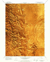
1967 Map of East Promontory
USGS Topo · Published 1970About this map
The Promontory Mountains define the western landscape of this mid-century survey, sloping down toward the extensive wetlands of the Bear River Migratory Bird Refuge. Water sources are vital features in this arid environment, evidenced by the numerous named points such as Sweetwater Spring, Wild Horse Spring, and Parsons Spring that dot the mountain flanks. The small settlement of East Promontory serves as a lone human outpost on the higher ground above the expansive Mud Flat and Bear River Bay.
Find a feature on this map
30 named features on this map. Tap any name to fly to it.
Don’t see what you’re looking for? This feature index may not catch every label — zoom into the map to look around manually.
Map Details
Editions of this 1967 East Promontory Map
2 editions found
Other maps of this area

1954 · Public Shooting Grounds
USGS Topo · 1:24,000

1954 · Brigham City
USGS Topo · 1:250,000

1955 · Willard Spur
USGS Topo · 1:24,000

1955 · Mouth of Bear River
USGS Topo · 1:24,000

1958 · Brigham City
USGS Topo · 1:250,000

1961 · Thatcher Mountain
USGS Topo · 1:62,500

1962 · Brigham City
USGS Topo · 1:250,000

1966 · Thatcher Mountain SW
USGS Topo · 1:24,000

1967 · Golden Spike Monument
USGS Topo · 1:24,000

1968 · Messix Peak
USGS Topo · 1:24,000