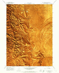
1967 Map of East Promontory
USGS Topo · Published 1972About this map
East Promontory occupies a strategic position where the steep ridges of the Promontory Mountains meet the vast flats of the Great Salt Lake shoreline. Surveyed in the late 1960s, this orthophotomap combines traditional topographic contours with aerial imagery to reveal the complex hydrology of the region. Numerous freshwater sources, including Parsons Spring, Sweetwater Spring, and Willow Springs, are critical landmarks along the eastern mountain base, providing essential water in an otherwise arid environment dominated by the Mud Flat and Sand Wash to the east.
Find a feature on this map
29 named features on this map. Tap any name to fly to it.
Don’t see what you’re looking for? This feature index may not catch every label — zoom into the map to look around manually.
Map Details
Editions of this 1967 East Promontory Map
2 editions found
Other maps of this area

1954 · Public Shooting Grounds
USGS Topo · 1:24,000

1954 · Brigham City
USGS Topo · 1:250,000

1955 · Willard Spur
USGS Topo · 1:24,000

1955 · Mouth of Bear River
USGS Topo · 1:24,000

1958 · Brigham City
USGS Topo · 1:250,000

1961 · Thatcher Mountain
USGS Topo · 1:62,500

1962 · Brigham City
USGS Topo · 1:250,000

1966 · Thatcher Mountain SW
USGS Topo · 1:24,000

1967 · Golden Spike Monument
USGS Topo · 1:24,000

1967 · East Promontory
USGS Topo · 1:24,000