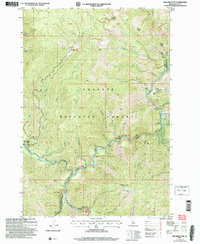
2004 Map of Williams Peak
USGS Topo · Published 2007About this map
The South Fork Salmon River and Secesh River converge in this remote Idaho landscape, forming a critical drainage network within the Payette National Forest. This 2004 revision, based on earlier topographic data, captures the intersection of natural waterways and early 20th-century resource extraction. Human activity is concentrated along the riverbanks and mountain flanks, evidenced by the Zena and Prospect mines and several historic forest outposts. Browns Camp and a dedicated Logging Camp sit near the western edge, while a Water Stop and Gaging Sta along the East Fork South Fork Salmon River highlight the era's reliance on stream flow and forest infrastructure. Rising above the river canyons, Williams Lookout Peak and Indian Point provide strategic vantage points over the steep drainage basins of Butterfly Creek and Pidgeon Creek.
Find a feature on this map
53 named features on this map. Tap any name to fly to it.
Don’t see what you’re looking for? This feature index may not catch every label — zoom into the map to look around manually.
Map Details
Editions of this 2004 Williams Peak Map
This is the sole edition of this map. No revisions or reprints were ever made.
Other maps of this area

1956 · Elk City
USGS Topo · 1:250,000

1957 · Challis
USGS Topo · 1:250,000

1960 · Elk City
USGS Topo · 1:250,000

1960 · Challis
USGS Topo · 1:250,000

1963 · Challis
USGS Topo · 1:250,000

1969 · Loon Lake
USGS Topo · 1:24,000

1969 · Pony Meadows
USGS Topo · 1:24,000

1969 · Enos Lake
USGS Topo · 1:24,000

1969 · Parks Peak
USGS Topo · 1:24,000

1969 · Williams Peak
USGS Topo · 1:24,000