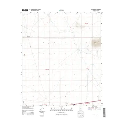
2013 Map of Williams Ranch
USGS Topo · Published 2013About this map
Williams Ranch serves as a primary landmark in this high-desert region of Luna County, where the desert floor is punctuated by the prominent heights of Black Mtn and Clabber Top Hill. The arid landscape is defined by the course of the Mimbres River, which winds through the northern and eastern sections of the quadrangle. The presence of the Imee Canal further south indicates the region's historical reliance on water management for ranching and agriculture. In the southern reaches, the settlement of Tunis is situated along a transportation corridor marked by Co Road C009. This survey provides a clear view of the rural infrastructure and natural drainage patterns that have shaped land use in this part of New Mexico, from the river's path to the isolated ranching outposts and roads.
Find a feature on this map
13 named features on this map. Tap any name to fly to it.
Don’t see what you’re looking for? This feature index may not catch every label — zoom into the map to look around manually.
Map Details
Editions of this 2013 Williams Ranch Map
This is the sole edition of this map. No revisions or reprints were ever made.
Other maps of this area

1899 · Deming
USGS Topo · 1:125,000

1915 · Deming
USGS Topo · 1:125,000

1954 · Silver City
USGS Topo · 1:250,000

1955 · Las Cruces
USGS Topo · 1:250,000

1958 · Las Cruces
USGS Topo · 1:250,000

1958 · Silver City
USGS Topo · 1:250,000

1962 · Silver City
USGS Topo · 1:250,000
1963 · Antelope Hill
USGS Topo · 1:24,000

1963 · Gage
USGS Topo · 1:24,000
1964 · Grandmother Mountain East
USGS Topo · 1:24,000