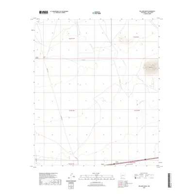
2020 Map of Williams Ranch
USGS Topo · Published 2020About this map
Williams Ranch and the small settlement of Tunis anchor this high-desert landscape in Luna County, where ranching and rail corridors converge. The ephemeral Mimbres River snakes through the central terrain, its course defined by wide draws and seasonal washes that shape the geography between Clabber Top Hill and the prominent Black Mtn. In the southern reaches, the map records the essential transport infrastructure of the modern era, showing where the I-10 Frontage Rd and local routes like Co RD d009 facilitate movement across the arid plains. Notable for its documentation of land divisions and rural landmarks, the survey includes Jones Spring Draw and numerous ranch roads that provide a detailed look at the connectivity of these remote holdings.
Find a feature on this map
16 named features on this map. Tap any name to fly to it.
Don’t see what you’re looking for? This feature index may not catch every label — zoom into the map to look around manually.
Map Details
Editions of this 2020 Williams Ranch Map
This is the sole edition of this map. No revisions or reprints were ever made.
Other maps of this area

1899 · Deming
USGS Topo · 1:125,000

1915 · Deming
USGS Topo · 1:125,000

1954 · Silver City
USGS Topo · 1:250,000

1955 · Las Cruces
USGS Topo · 1:250,000

1958 · Las Cruces
USGS Topo · 1:250,000

1958 · Silver City
USGS Topo · 1:250,000

1962 · Silver City
USGS Topo · 1:250,000
1963 · Antelope Hill
USGS Topo · 1:24,000

1963 · Gage
USGS Topo · 1:24,000
1964 · Grandmother Mountain East
USGS Topo · 1:24,000