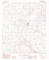
1985 Map of Williams Sink
USGS Topo · Published 1985About this map
Williams Sink and the surrounding alkaline flats of the Permian Basin dominate this 1980s landscape, reflecting an environment heavily shaped by the regional potash and petroleum industries. The topography is defined by significant industrial infrastructure, including numerous Mine Shafts, extensive Tailings piles, and specialized water management features like the Laguna Toston Disposal Pond. A network of utility features, including a Pumping Sta and a prominent Radio Tower, supports the operations occurring across the county line between Eddy and Lea counties.
Find a feature on this map
13 named features on this map. Tap any name to fly to it.
Don’t see what you’re looking for? This feature index may not catch every label — zoom into the map to look around manually.
Map Details
Editions of this 1985 Williams Sink Map
This is the sole edition of this map. No revisions or reprints were ever made.
Other maps of this area

1939 · Nash Draw
USGS Topo · 1:62,500

1942 · Clayton Basin
USGS Topo · 1:62,500

1943 · Clayton Basin
USGS Topo · 1:62,500

1943 · Nash Draw
USGS Topo · 1:62,500

1954 · Hobbs
USGS Topo · 1:250,000

1958 · Hobbs
USGS Topo · 1:250,000

1963 · Laguna Gatuna
USGS Topo · 1:62,500

1963 · Hat Mesa
USGS Topo · 1:62,500

1978 · Jal
USGS Topo · 1:100,000

1984 · Laguna Gatuna NW
USGS Topo · 1:24,000