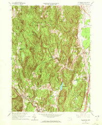
1964 Map of Williamsburg
USGS Topo · Published 1972About this map
The Mill River valley anchors this mid-century topographic record, tracing a network of settlements from Williamsburg and Haydenville in the south to the uplands of Conway State Forest. The era's industrial and transit legacy is visible along the Boston and Maine railroad line, which serves Williamsburg Station near the Brass Millpond. To the east, the landscape transitions into the agricultural and residential pockets of Whately Center and Westbrook, where civic life is marked by the Whately Center Sch and local cemeteries.
Find a feature on this map
78 named features on this map. Tap any name to fly to it.
Don’t see what you’re looking for? This feature index may not catch every label — zoom into the map to look around manually.
Map Details
Editions of this 1964 Williamsburg Map
4 editions found
Other maps of this area

1885 · Northampton
USGS Topo · 1:62,500

1886 · Hawley
USGS Topo · 1:62,500

1886 · Chesterfield
USGS Topo · 1:62,500

1886 · Northampton
USGS Topo · 1:62,500

1888 · Chesterfield
USGS Topo · 1:62,500

1890 · Hawley
USGS Topo · 1:62,500

1890 · Greenfield
USGS Topo · 1:62,500

1891 · Northampton
USGS Topo · 1:62,500

1893 · Northampton
USGS Topo · 1:62,500

1893 · Chesterfield
USGS Topo · 1:62,500