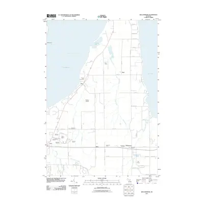
2011 Map of Williamsburg
USGS Topo · Published 2011About this map
East Arm Grand Traverse Bay and the shoreline of Lake Michigan define this landscape, where recreation and agriculture meet along the coast. The terrain is deeply carved by waterways like Tobeco Creek and Yuba Creek, which flow toward the bay through a mix of orchards and growing settlements. This 2011 survey captures the area’s transition into a premier golf and leisure destination, marked by the expansive Grand Traverse Resort, Wolverine Golf Course, and Bear Golf Course. For genealogists and local historians, the map identifies key community anchors such as the Williamsburg Post Office and several burial grounds, including the Yuba Acme Township Cemetery and Circle Hill Cemetery. The interior reveals a dense network of local roads serving small hubs like Bates and Williamsburg, while the northern reaches remain more open near Petobego Pond.
Find a feature on this map
68 named features on this map. Tap any name to fly to it.
Don’t see what you’re looking for? This feature index may not catch every label — zoom into the map to look around manually.
Map Details
Editions of this 2011 Williamsburg Map
This is the sole edition of this map. No revisions or reprints were ever made.
Other maps of this area

1954 · Traverse City
USGS Topo · 1:250,000

1956 · Fife Lake
USGS Topo · 1:62,500

1956 · Kingsley
USGS Topo · 1:62,500

1957 · Traverse City
USGS Topo · 1:62,500

1957 · Elk Rapids
USGS Topo · 1:62,500

1958 · Traverse City
USGS Topo · 1:250,000

1983 · Traverse City SE
USGS Topo · 1:25,000

1983 · Traverse City
USGS Topo · 1:100,000
1983 · Elk Rapids
USGS Topo · 1:25,000
1983 · Mapleton
USGS Topo · 1:25,000
Featured Places
- Peninsula Township, MI
- Acme Township, MI
- Whitewater Township, MI
- Yuba, Acme Township
- Angel, Whitewater Township