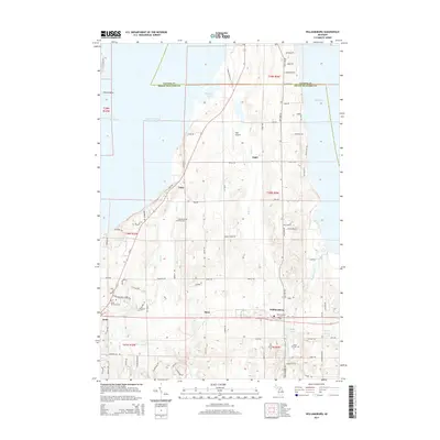
2014 Map of Williamsburg
USGS Topo · Published 2014About this map
East Arm Grand Traverse Bay and Elk Lake frame a peninsula of rolling cherry orchards and small lakeside settlements. In the early 21st century, the village of Williamsburg remains a focal point in the southeast, while the smaller communities of Yuba, Angel, and Bates dot the landscape of Grand Traverse County. The terrain is marked by a complex network of creeks including Yuba Cr and Tobeco Cr, which flow toward the bay and define the drainage patterns of the area.
Find a feature on this map
91 named features on this map. Tap any name to fly to it.
Don’t see what you’re looking for? This feature index may not catch every label — zoom into the map to look around manually.
Map Details
Editions of this 2014 Williamsburg Map
This is the sole edition of this map. No revisions or reprints were ever made.
Other maps of this area

1954 · Traverse City
USGS Topo · 1:250,000

1956 · Fife Lake
USGS Topo · 1:62,500

1956 · Kingsley
USGS Topo · 1:62,500

1957 · Traverse City
USGS Topo · 1:62,500

1957 · Elk Rapids
USGS Topo · 1:62,500

1958 · Traverse City
USGS Topo · 1:250,000

1983 · Traverse City SE
USGS Topo · 1:25,000

1983 · Traverse City
USGS Topo · 1:100,000
1983 · Elk Rapids
USGS Topo · 1:25,000
1983 · Mapleton
USGS Topo · 1:25,000
Featured Places
- Peninsula Township, MI
- Acme Township, MI
- Whitewater Township, MI
- Yuba, Acme Township
- Angel, Whitewater Township