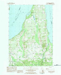
1983 Map of Williamsburg
USGS Topo · Published 1984About this map
Grand Traverse Bay and the wooded coast of the East Arm dominate this 1980s landscape, where small communities like Acme and Williamsburg serve as anchors for the surrounding rural roads. The area shows a transition between conservation lands and local industry, marked by the extensive Petobego State Game Area and several gravel pits. In Whitewater and Acme townships, the presence of Township Cem, Circle Hill Cem, and the Bates Ch provides a clear view of the established social fabric of these villages.
Find a feature on this map
59 named features on this map. Tap any name to fly to it.
Don’t see what you’re looking for? This feature index may not catch every label — zoom into the map to look around manually.
Map Details
Editions of this 1983 Williamsburg Map
This is the sole edition of this map. No revisions or reprints were ever made.
Other maps of this area

1954 · Traverse City
USGS Topo · 1:250,000

1956 · Fife Lake
USGS Topo · 1:62,500

1956 · Kingsley
USGS Topo · 1:62,500

1957 · Traverse City
USGS Topo · 1:62,500

1957 · Elk Rapids
USGS Topo · 1:62,500

1958 · Traverse City
USGS Topo · 1:250,000

1983 · Traverse City SE
USGS Topo · 1:25,000

1983 · Traverse City
USGS Topo · 1:100,000
1983 · Elk Rapids
USGS Topo · 1:25,000
1983 · Mapleton
USGS Topo · 1:25,000
Featured Places
- Peninsula Township, MI
- Acme Township, MI
- Whitewater Township, MI
- Milton Township, MI
- Yuba, Acme Township