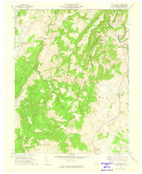
1972 Map of Williamsburg
USGS Topo · Published 1974About this map
Williamsburg sits at the western edge of this Greenbrier County survey, where the landscape transitions from the high ridges of Brushy Ridge and Muller Ridge into the agricultural valleys of central West Virginia. The drainage patterns here are particularly distinct, dominated by the winding paths of Sinking Creek and Culbertson Creek as they navigate the complex topography of Raders Valley. The distribution of small settlements like Unus, Sunlight, and Brantville reflects a rural economy rooted in the land's limestone-rich geology, evidenced by a Quarry and a Gas Well near the northern boundary.
Find a feature on this map
32 named features on this map. Tap any name to fly to it.
Don’t see what you’re looking for? This feature index may not catch every label — zoom into the map to look around manually.
Map Details
Editions of this 1972 Williamsburg Map
This is the sole edition of this map. No revisions or reprints were ever made.
Other maps of this area

1887 · Hinton
USGS Topo · 1:125,000

1887 · Lewisburg
USGS Topo · 1:125,000

1889 · Nicholas
USGS Topo · 1:125,000

1891 · Lewisburg
USGS Topo · 1:125,000

1891 · Nicholas
USGS Topo · 1:125,000

1891 · Huntersville
USGS Topo · 1:125,000

1892 · Hinton
USGS Topo · 1:125,000

1894 · Huntersville
USGS Topo · 1:125,000

1901 · Nicholas
USGS Topo · 1:125,000

1918 · Richwood
USGS Topo · 1:62,500