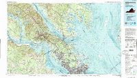
1984 Map of Williamsburg
USGS Topo · Published 1990About this map
College of William and Mary anchors the historic core of this Tidewater survey, illustrating a landscape defined by its proximity to the massive estuaries of the James River and York River. By the early 1980s, the region demonstrates a dense layering of colonial heritage and modern strategic importance, where the Colonial National Historical Park and Jamestown Island sit adjacent to significant military and scientific installations. The corridor between Newport News and Hampton is heavily developed, featuring the NASA Langley Research Center and Langley Air Force Base.
Find a feature on this map
94 named features on this map. Tap any name to fly to it.
Don’t see what you’re looking for? This feature index may not catch every label — zoom into the map to look around manually.
Map Details
Editions of this 1984 Williamsburg Map
3 editions found
Other maps of this area

1893 · Virginia Beach
USGS Topo · 1:125,000

1906 · Williamsburg
USGS Topo · 1:62,500

1907 · Norfolk
USGS Topo · 1:125,000

1907 · Yorktown
USGS Topo · 1:62,500

1907 · Hampton
USGS Topo · 1:62,500

1916 · Kilmarnock
USGS Topo · 1:48,000

1916 · Mathews
USGS Topo · 1:62,500

1917 · Urbanna
USGS Topo · 1:62,500

1917 · Kilmarnock
USGS Topo · 1:62,500

1917 · Mathews
USGS Topo · 1:62,500