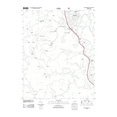
2010 Map of Williamsburg
USGS Topo · Published 2010About this map
Williamsburg serves as the focal point for this southern Kentucky survey, where the Cumberland River loops past Highland Park and the Highland Cemetery. The landscape is defined by the sharp transition from the river valley to the complex ridges of Jellico Mountain and Grassy Mountain to the west. Evidence of the region’s timber and mining heritage is visible in the numerous named hollows, such as Coal Bank Hollow and Deadening Hollow, and the string of small settlements that follow the Clear Fork valley. Transport corridors and drainage patterns are deeply intertwined here, with small communities like Savoy, Emlyn, and Mountain Ash established along the rail and road routes that skirt Hog Jowl Mountain. To the south, the terrain becomes increasingly intricate, featuring family-named landmarks like Sugar Betty Hollow and Fate Lee Mountain, alongside the remote Ayers settlement near the winding Ross Branch.
Find a feature on this map
85 named features on this map. Tap any name to fly to it.
Don’t see what you’re looking for? This feature index may not catch every label — zoom into the map to look around manually.
Map Details
Editions of this 2010 Williamsburg Map
This is the sole edition of this map. No revisions or reprints were ever made.
Other maps of this area

1890 · Williamsburg
USGS Topo · 1:125,000

1894 · Williamsburg
USGS Topo · 1:125,000

1952 · Wofford
USGS Topo · 1:24,000

1952 · Saxton
USGS Topo · 1:24,000

1952 · Hollyhill
USGS Topo · 1:24,000

1952 · Rockholds
USGS Topo · 1:24,000

1952 · Cumberland Falls
USGS Topo · 1:24,000

1952 · Williamsburg
USGS Topo · 1:24,000
1953 · Jellico West
USGS Topo · 1:24,000
1953 · Jellico East
USGS Topo · 1:24,000