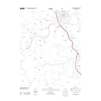
2013 Map of Williamsburg
USGS Topo · Published 2013About this map
The Cumberland River curves through the heart of Williamsburg, framing a landscape defined by the deep incisions of the Clear Fork and Wolf Cr. In the early 21st century, the regional layout reflects a mix of dense municipal street grids and the scattered smaller communities of Savoy, Balltown, and Bon. Higher elevations like Jellico Mountain and Bon Jellico Mountain are marked by numerous hollows, such as Deadening Hollow and Coal Bank Hollow, which point to the area's geological and industrial heritage. For those tracing local families, the map identifies significant burial sites including Highland Cem and Whitley County Cem. The presence of the Shelly Knob Lookout on the high ground south of Jellico Creek provides a perspective on the terrain that separates the river valley from the southern reaches of Ayers.
Find a feature on this map
117 named features on this map. Tap any name to fly to it.
Don’t see what you’re looking for? This feature index may not catch every label — zoom into the map to look around manually.
Map Details
Editions of this 2013 Williamsburg Map
This is the sole edition of this map. No revisions or reprints were ever made.
Other maps of this area

1890 · Williamsburg
USGS Topo · 1:125,000

1894 · Williamsburg
USGS Topo · 1:125,000

1952 · Wofford
USGS Topo · 1:24,000

1952 · Saxton
USGS Topo · 1:24,000

1952 · Hollyhill
USGS Topo · 1:24,000

1952 · Rockholds
USGS Topo · 1:24,000

1952 · Cumberland Falls
USGS Topo · 1:24,000

1952 · Williamsburg
USGS Topo · 1:24,000
1953 · Jellico West
USGS Topo · 1:24,000
1953 · Jellico East
USGS Topo · 1:24,000