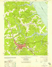
1952 Map of Williamsburg
USGS Topo · Published 1957About this map
William and Mary College and the surrounding restored colonial capital dominate the landscape of the Virginia Peninsula in this early 1950s record. The map captures a moment of significant military presence, with the sprawling Naval Training Station Camp Peary and Naval Supply Depot Cheatham Annex bordering the York River. Modern infrastructure like the Colonial National Historical Parkway and the Chesapeake and Ohio railroad weave through historical landmarks, including the Capitol and the Fort Magruder Ruins. This map reveals the intersection of institutional growth and historical preservation, featuring facilities like the Eastern State Mental Hospital and Bruton Heights School alongside traditional rural corners like Skimino and Oaktree. The intricate network of tidal waterways, such as Queen Creek and Skimino Creek, reflects the coastal geography that shaped the region’s early defensive and commercial importance.
Find a feature on this map
57 named features on this map. Tap any name to fly to it.
Don’t see what you’re looking for? This feature index may not catch every label — zoom into the map to look around manually.
Map Details
Editions of this 1952 Williamsburg Map
This is the sole edition of this map. No revisions or reprints were ever made.
Other maps of this area

1906 · Williamsburg
USGS Topo · 1:62,500

1907 · Yorktown
USGS Topo · 1:62,500

1917 · Toano
USGS Topo · 1:62,500

1918 · Toano
USGS Topo · 1:62,500

1919 · Surry
USGS Topo · 1:62,500

1943 · Yorktown
USGS Topo · 1:62,500

1943 · Richmond
USGS Topo · 1:250,000

1944 · Yorktown
USGS Topo · 1:24,000

1949 · Richmond
USGS Topo · 1:250,000

1950 · Cobham Bay
USGS Topo · 1:24,000