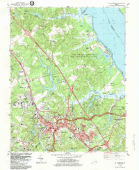
1984 Map of Williamsburg
USGS Topo · Published 1984This historical map portrays the area of Williamsburg in 1984, primarily covering Williamsburg as well as portions of Oaktree, Skimino, and Banbury Cross. Featuring a scale of 1:24,000, this map provides a highly detailed snapshot of the terrain, roads, buildings, counties, and historical landmarks in the Williamsburg region at the time. Published in 1984, it is one of 2 known editions of this map due to revisions or reprints.
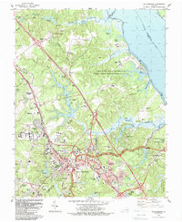
Map Details
Editions of this 1984 Williamsburg Map
2 editions found
Other maps of this area

1906 · Williamsburg
USGS Topo · 1:62,500

1907 · Yorktown
USGS Topo · 1:62,500

1917 · Toano
USGS Topo · 1:62,500

1918 · Toano
USGS Topo · 1:62,500

1919 · Surry
USGS Topo · 1:62,500

1943 · Yorktown
USGS Topo · 1:62,500

1943 · Richmond
USGS Topo · 1:250,000

1944 · Yorktown
USGS Topo · 1:24,000

1949 · Richmond
USGS Topo · 1:250,000

1950 · Cobham Bay
USGS Topo · 1:24,000