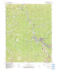
1992 Map of Williamson
USGS Topo · Published 1992About this map
Tug Fork and the Tug River wind through this coal-country landscape along the state border between West Virginia and Kentucky. The industrial hub of Williamson dominates the lower valley, showing a complex of rail yards and commercial infrastructure associated with the Norfolk and Western line. This 1990s-era survey documents the intense development along the river banks, with settlements like South Williamson and West Williamson flanking the central corporate limits, while the Mingo County Airport occupies the high ground to the east.
Find a feature on this map
87 named features on this map. Tap any name to fly to it.
Don’t see what you’re looking for? This feature index may not catch every label — zoom into the map to look around manually.
Map Details
Editions of this 1992 Williamson Map
This is the sole edition of this map. No revisions or reprints were ever made.
Other maps of this area

1887 · Warfield
USGS Topo · 1:125,000

1891 · Warfield
USGS Topo · 1:125,000

1909 · Matewan
USGS Topo · 1:48,000

1910 · Holden
USGS Topo · 1:48,000

1910 · Naugatuck
USGS Topo · 1:48,000

1912 · Naugatuck
USGS Topo · 1:62,500

1912 · Holden
USGS Topo · 1:62,500

1915 · Williamson
USGS Topo · 1:48,000

1915 · Naugatuck
USGS Topo · 1:48,000

1915 · Matewan
USGS Topo · 1:48,000