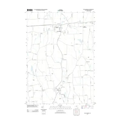
2013 Map of Williamson
USGS Topo · Published 2013About this map
Williamson and Marion serve as the primary anchors for this region of Wayne County, defined by a landscape where agricultural heritage meets local aviation. The terrain is marked by distinctive rises such as Pigeon Hill, Cory Hill, and Prospect Hill, which influence the drainage patterns of Red Cr and Salmon Cr. A strong genealogical record is preserved across numerous burial grounds, including the Ridge Chapel Cem, Marion Village Cem, and Hall Center Cem, reflecting the distribution of early family settlements near crossroad hamlets like Cory Corners and Owls Nest. The presence of the Williamson-Sodus Airport and the smaller Ag-Alley Airport highlights the area's ongoing connection to regional transport and crop dusting. Notable local entities such as CC Farms, Mason Farms, and Frankes Nursery emphasize the persistent agricultural character of the land north of the major thoroughfares.
Find a feature on this map
109 named features on this map. Tap any name to fly to it.
Don’t see what you’re looking for? This feature index may not catch every label — zoom into the map to look around manually.
Map Details
Editions of this 2013 Williamson Map
This is the sole edition of this map. No revisions or reprints were ever made.
Other maps of this area

1899 · Palmyra
USGS Topo · 1:62,500

1900 · Macedon
USGS Topo · 1:62,500

1902 · Pultneyville
USGS Topo · 1:62,500

1902 · Palmyra
USGS Topo · 1:62,500

1942 · Ontario
USGS Topo · 1:31,680

1942 · Pultneyville
USGS Topo · 1:31,680

1943 · Williamson
USGS Topo · 1:31,680

1943 · Sodus
USGS Topo · 1:31,680
1943 · Newark
USGS Topo · 1:31,680
1943 · Palmyra
USGS Topo · 1:31,680