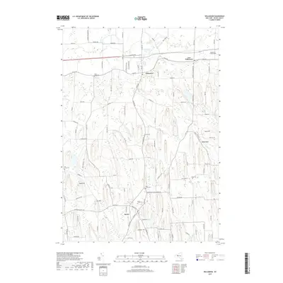
2019 Map of Williamson
USGS Topo · Published 2019About this map
Glacial drumlins dictate the north-south orientation of the landscape between Williamson and Marion, where local orchards and agriculture thrive alongside numerous watercourses. The drainage of Salmon Cr and Mink Cr weaves through the lowlands, while the community of East Williamson sits along the historic Ridge Rd corridor. This 2019 survey documents a region deeply rooted in its cemetery records, with sites like Ridge Chapel Cem and Hall Center Cem providing essential landmarks for genealogical research. The local economy is reflected in the presence of the Williamson-Sodus Airport and the network of local roads such as Stoney Lonesome Rd and Tuckahoe Rd that connect the scattered settlements. Prominent elevations including Pigeon Hill and Cory Hill rise above the agricultural flats, defining the topographic character of Wayne County.
Find a feature on this map
100 named features on this map. Tap any name to fly to it.
Don’t see what you’re looking for? This feature index may not catch every label — zoom into the map to look around manually.
Map Details
Editions of this 2019 Williamson Map
This is the sole edition of this map. No revisions or reprints were ever made.
Other maps of this area

1899 · Palmyra
USGS Topo · 1:62,500

1900 · Macedon
USGS Topo · 1:62,500

1902 · Pultneyville
USGS Topo · 1:62,500

1902 · Palmyra
USGS Topo · 1:62,500

1942 · Ontario
USGS Topo · 1:31,680

1942 · Pultneyville
USGS Topo · 1:31,680

1943 · Williamson
USGS Topo · 1:31,680

1943 · Sodus
USGS Topo · 1:31,680
1943 · Newark
USGS Topo · 1:31,680
1943 · Palmyra
USGS Topo · 1:31,680