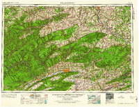
1960 Map of Williamsport
USGS Topo · Published 1960About this map
The West Branch Susquehanna River carves a deep path through the central Pennsylvania highlands, anchoring a landscape of industrial river towns and steep ridges. At the heart of the region, Williamsport serves as a major hub where the Pennsylvania RR and U.S. 220 intersect. The map illustrates a complex network of transportation and military presence, notably the Susquehanna Ordnance Depot near Milton.
Find a feature on this map
64 named features on this map. Tap any name to fly to it.
Don’t see what you’re looking for? This feature index may not catch every label — zoom into the map to look around manually.
Map Details
Editions of this 1960 Williamsport Map
This is the sole edition of this map. No revisions or reprints were ever made.
Other maps of this area

1889 · Catawissa
USGS Topo · 1:62,500

1889 · Hazleton
USGS Topo · 1:62,500

1891 · Wilkesbarre
USGS Topo · 1:62,500

1891 · Hazleton
USGS Topo · 1:62,500

1891 · Harveys Lake
USGS Topo · 1:62,500

1892 · Catawissa
USGS Topo · 1:62,500

1892 · Shamokin
USGS Topo · 1:62,500

1892 · Mahanoy
USGS Topo · 1:62,500

1893 · Hazleton
USGS Topo · 1:62,500
1893 · Sunbury
USGS Topo · 1:62,500