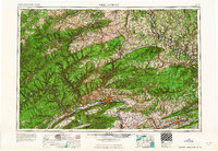
1965 Map of Williamsport
USGS Topo · Published 1965About this map
The West Branch Susquehanna River carves a dominant path through the center of this landscape, anchoring the industrial and residential growth of Williamsport, Montoursville, and Jersey Shore. South of the river, the dramatic ridges of Bald Eagle Mountain and Nittany Mountain define the valley limits, while to the north, the massive timberlands of Susquehannock State Forest and Tioga State Forest dominate the Allegheny Plateau.
Find a feature on this map
107 named features on this map. Tap any name to fly to it.
Don’t see what you’re looking for? This feature index may not catch every label — zoom into the map to look around manually.
Map Details
Editions of this 1965 Williamsport Map
This is the sole edition of this map. No revisions or reprints were ever made.
Other maps of this area

1889 · Catawissa
USGS Topo · 1:62,500

1889 · Hazleton
USGS Topo · 1:62,500

1891 · Wilkesbarre
USGS Topo · 1:62,500

1891 · Hazleton
USGS Topo · 1:62,500

1891 · Harveys Lake
USGS Topo · 1:62,500

1892 · Catawissa
USGS Topo · 1:62,500

1892 · Shamokin
USGS Topo · 1:62,500

1892 · Mahanoy
USGS Topo · 1:62,500

1893 · Hazleton
USGS Topo · 1:62,500
1893 · Sunbury
USGS Topo · 1:62,500