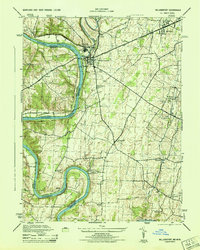
1944 Map of Williamsport
USGS Topo · Published 1944About this map
The Potomac River forms a serpentine boundary between Washington and Berkeley counties during the mid-1940s, a period when the river valley remained a vital corridor for transportation and education. The Chesapeake and Ohio Canal parallels the river's northern bank, passing through the major settlement of Williamsport. This industrial and transit hub is supported by a dense network of railroads, including the Western Maryland and Pennsylvania lines. South of the main town, the landscape is dotted with rural educational institutions and milling sites, such as the St James School and the Cedar Grove Mill. The presence of numerous small stations like Pinesburg Sta and St James Sta illustrates the localized nature of the rail economy, while the sharp turn at Potomac Bend and the prominence of Whitings Neck highlight the river's significant influence on the area's development.
Find a feature on this map
36 named features on this map. Tap any name to fly to it.
Don’t see what you’re looking for? This feature index may not catch every label — zoom into the map to look around manually.
Map Details
Editions of this 1944 Williamsport Map
2 editions found
Other maps of this area

1884 · Harpers Ferry
USGS Topo · 1:125,000

1891 · Harpers Ferry
USGS Topo · 1:125,000

1893 · Harpers Ferry
USGS Topo · 1:125,000

1908 · Middletown
USGS Topo · 1:48,000

1909 · Hagerstown
USGS Topo · 1:48,000

1910 · Antietam
USGS Topo · 1:62,500

1912 · Hagerstown
USGS Topo · 1:62,500

1912 · Williamsport
USGS Topo · 1:62,500

1914 · Martinsburg
USGS Topo · 1:48,000

1916 · Martinsburg
USGS Topo · 1:62,500