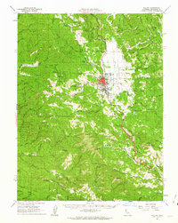
1961 Map of Willits
USGS Topo · Published 1963About this map
The mountain town of Willits serves as a critical junction for Mendocino County's interior and coastal transportation networks during the early 1960s. The city is the meeting point for U.S. Highway 101 and the Northwestern Pacific RR, while the California Western railroad strikes westward toward the coast through rugged gaps like Summit. This survey documents the valley's development, featuring the Union High Sch, the Airport, and the regional Mendocino County CDF Hdqrs. Beyond the valley floor, the landscape transitions into the heavily timbered terrain of the Jackson State Forest. Remnants of earlier settlement and industry appear in the form of remote ranch sites such as the Hans Ottoson Opening and Upper Ranch Opening, alongside small rail stops like Shake City and Irmulco nestled along the Noyo River.
Find a feature on this map
99 named features on this map. Tap any name to fly to it.
Don’t see what you’re looking for? This feature index may not catch every label — zoom into the map to look around manually.
Map Details
Editions of this 1961 Willits Map
3 editions found
Other maps of this area

1920 · Glenblair
USGS Topo · 1:62,500

1920 · Ukiah
USGS Topo · 1:62,500

1921 · Branscomb
USGS Topo · 1:62,500

1922 · Willits
USGS Topo · 1:62,500

1929 · Eden Valley
USGS Topo · 1:62,500

1942 · Willits
USGS Topo · 1:62,500

1943 · Glenblair
USGS Topo · 1:62,500

1943 · Pomo
USGS Topo · 1:62,500

1943 · Boonville
USGS Topo · 1:62,500

1943 · Navarro
USGS Topo · 1:62,500