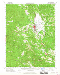
1961 Map of Willits
USGS Topo · Published 1967About this map
Willits serves as the central hub of this northern California landscape, where the Northwestern Pacific Railroad and U.S. Route 101 converge in the valley. The map documents a rugged timber and ranching environment characterized by small settlements and rail stops like Shake City, Irmulco, and Clare Mill. The presence of the Mendocino County C.D.F. Headquarters and the Jackson State Forest boundary indicates the vital role of forestry and fire management in the region. Water management is evident through features like Morris Dam and the Settling Tank, supporting the local infrastructure. For genealogists and local historians, the map provides precise locations for the Little Lake Cemetery and several named mountain openings, such as Hans Ottoson Opening and Upper Ranch Opening, which suggest legacy landholdings in the hills surrounding the Little Lake Valley.
Find a feature on this map
85 named features on this map. Tap any name to fly to it.
Don’t see what you’re looking for? This feature index may not catch every label — zoom into the map to look around manually.
Map Details
Editions of this 1961 Willits Map
3 editions found
Other maps of this area

1920 · Glenblair
USGS Topo · 1:62,500

1920 · Ukiah
USGS Topo · 1:62,500

1921 · Branscomb
USGS Topo · 1:62,500

1922 · Willits
USGS Topo · 1:62,500

1929 · Eden Valley
USGS Topo · 1:62,500

1942 · Willits
USGS Topo · 1:62,500

1943 · Glenblair
USGS Topo · 1:62,500

1943 · Pomo
USGS Topo · 1:62,500

1943 · Boonville
USGS Topo · 1:62,500

1943 · Navarro
USGS Topo · 1:62,500