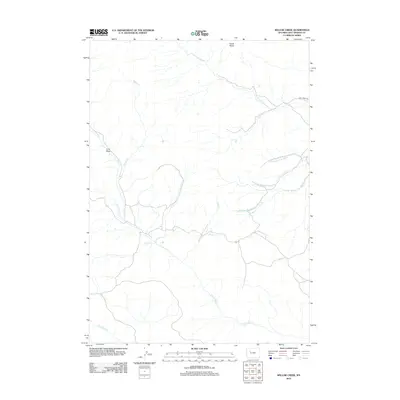
2012 Map of Willow Creek
USGS Topo · Published 2012About this map
Castle Rocks stands as a prominent landmark in this drainage-rich portion of Hot Springs County, where the landscape is defined by the intricate headwaters of the Owl Creek system. The map reveals a complex network of seasonal and perennial streams, including the southern reaches of Willow Creek and the winding South Fork Owl Creek. This area illustrates a classic Western rangeland pattern, where limited transportation infrastructure like Owl Creek Road follows the natural contours of the valley floors to connect remote ranching or grazing lands.
Find a feature on this map
14 named features on this map. Tap any name to fly to it.
Don’t see what you’re looking for? This feature index may not catch every label — zoom into the map to look around manually.
Map Details
Editions of this 2012 Willow Creek Map
This is the sole edition of this map. No revisions or reprints were ever made.
Other maps of this area

1904 · Kirwin
USGS Topo · 1:125,000

1906 · Kirwin
USGS Topo · 1:125,000

1952 · Antelope Ridge
USGS Topo · 1:24,000

1955 · Thermopolis
USGS Topo · 1:250,000

1956 · Milk Creek
USGS Topo · 1:24,000

1958 · Thermopolis
USGS Topo · 1:250,000

1962 · Thermopolis
USGS Topo · 1:250,000
1965 · Eagle Nest Ranch
USGS Topo · 1:24,000

1967 · Willow Creek
USGS Topo · 1:24,000
1967 · Circle Ridge
USGS Topo · 1:24,000