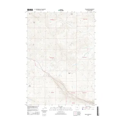
2015 Map of Willow Creek
USGS Topo · Published 2015About this map
The Absaroka Range and the Owl Creek Mountains meet in this high-altitude corner of Hot Springs County, Wyoming. The terrain is defined by a dense network of drainage systems, including the headwaters of Willow Cr and Rock Cr, which flow through deeply carved topography such as Buckle Draw and Black Draw. These natural corridors dictate the movement of water and travelers across the high desert and mountain landscape.
Find a feature on this map
25 named features on this map. Tap any name to fly to it.
Don’t see what you’re looking for? This feature index may not catch every label — zoom into the map to look around manually.
Map Details
Editions of this 2015 Willow Creek Map
This is the sole edition of this map. No revisions or reprints were ever made.
Other maps of this area

1904 · Kirwin
USGS Topo · 1:125,000

1906 · Kirwin
USGS Topo · 1:125,000

1952 · Antelope Ridge
USGS Topo · 1:24,000

1955 · Thermopolis
USGS Topo · 1:250,000

1956 · Milk Creek
USGS Topo · 1:24,000

1958 · Thermopolis
USGS Topo · 1:250,000

1962 · Thermopolis
USGS Topo · 1:250,000
1965 · Eagle Nest Ranch
USGS Topo · 1:24,000

1967 · Willow Creek
USGS Topo · 1:24,000
1967 · Circle Ridge
USGS Topo · 1:24,000