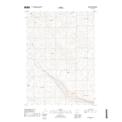
2018 Map of Willow Creek
USGS Topo · Published 2018About this map
The Absaroka Range and the Owl Creek Mountains converge in this high-elevation landscape of Hot Springs County, Wyoming. The terrain is defined by a series of steep drainages and watercourses, including S Fork Owl Cr and Willow Cr. Notable landmarks such as Castle Rocks dominate the northern horizons, while the land is carved by numerous erosion features like Black Draw, Buckle Draw, and Love Draw.
Find a feature on this map
23 named features on this map. Tap any name to fly to it.
Don’t see what you’re looking for? This feature index may not catch every label — zoom into the map to look around manually.
Map Details
Editions of this 2018 Willow Creek Map
This is the sole edition of this map. No revisions or reprints were ever made.
Other maps of this area

1904 · Kirwin
USGS Topo · 1:125,000

1906 · Kirwin
USGS Topo · 1:125,000

1952 · Antelope Ridge
USGS Topo · 1:24,000

1955 · Thermopolis
USGS Topo · 1:250,000

1956 · Milk Creek
USGS Topo · 1:24,000

1958 · Thermopolis
USGS Topo · 1:250,000

1962 · Thermopolis
USGS Topo · 1:250,000
1965 · Eagle Nest Ranch
USGS Topo · 1:24,000

1967 · Willow Creek
USGS Topo · 1:24,000
1967 · Circle Ridge
USGS Topo · 1:24,000